Kidhar: Indoor Mapping
I spent my third summer of college doing an internship at Ericsson India. I was expecting to be working on something related to their technologies in computer networks, but what I finally ended up doing was something far more exciting than that. An application that gives people directions within a building! The building may be a mall, an airport, an office building, or even your own home!
This was a very exciting project because it was the first project for which I had a clear goal and a strict deadline. The whole thing, from implementing Dijkstra's algorithm for pathfinding to setting up a server to host the code, was done in under a month. A month filled with some intense ideation and coding. Overall, I had a wonderful experience at the Ericsson India office developing an application that is actually being used there today!
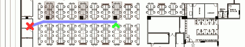
The application is a bunch of python code running on a remote server. Users scan QR codes with their mobile phones. The code translates to a URL which is sent to the server. The URL encodes the source and destination of the user. The server then figures out the best path from source to destination and sends back an image of the map and the path which is displayed in a browser window.
Too much technicality? Try it yourself!
This was a very exciting project because it was the first project for which I had a clear goal and a strict deadline. The whole thing, from implementing Dijkstra's algorithm for pathfinding to setting up a server to host the code, was done in under a month. A month filled with some intense ideation and coding. Overall, I had a wonderful experience at the Ericsson India office developing an application that is actually being used there today!
The application is a bunch of python code running on a remote server. Users scan QR codes with their mobile phones. The code translates to a URL which is sent to the server. The URL encodes the source and destination of the user. The server then figures out the best path from source to destination and sends back an image of the map and the path which is displayed in a browser window.
Too much technicality? Try it yourself!
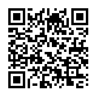
Just scan this code with a QR code reader on your mobile phone!
This is a sample showing you what a map would look like.
|
